

Maritime Security and Safety
Special Report: Know Your Navigation Marks

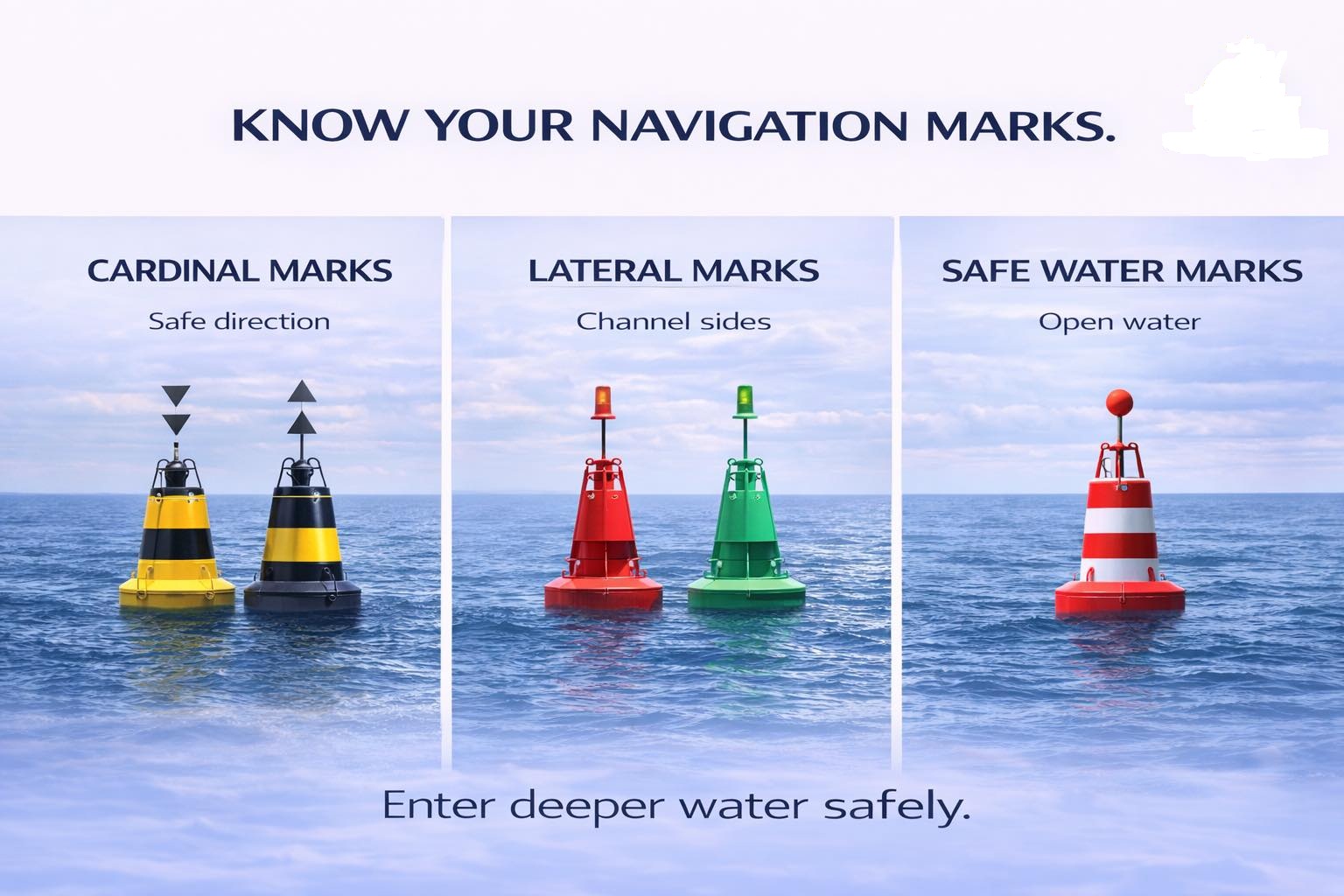

KNOW YOUR NAVIGATION MARKS
Out at sea, there are no roads, no lanes, no traffic lights — yet ships move safely every single day. Here is how.
SPECIAL REPORT | NAVIGATION & SAFETY :By Raymond Gold O. | Co-publisher & Research Reporter | Waterways News
The ocean is vast, unforgiving, and utterly unmarked by the familiar grid of roads that govern movement on land. No white lines divide one lane from another. No traffic officers wave ships into position. No overhead signs point toward a distant port. And yet, in one of the oldest and most remarkable feats of human coordination, thousands of vessels — from artisanal canoes to thousand-foot supertankers — navigate these waters in disciplined, near-flawless order. The secret is not technology alone. The secret is a universal language of marks.
Navigation marks are the vocabulary of the sea. They are the silent sentinels posted at critical junctures in the waterway — warning of danger here, confirming safe passage there, defining the channels through which commerce and livelihood flow. To the untrained eye, a buoy bobbing off the Lagos shoreline or the Niger Delta estuary may look like a modest piece of hardware. To the mariner who knows the system, it is as clear and authoritative as a highway sign. This special report, produced by the research desk of Waterways News, unpacks the three primary families of navigation marks that govern maritime movement the world over: Cardinal Marks, Lateral Marks, and Safe Water Marks.

“At sea, you don’t rely on instinct. You rely on marks, systems, and rules — and that discipline is what keeps every vessel alive.”
PART ONE: CARDINAL MARKS — WHERE SAFETY LIVES
Of all the mark types in use across the world’s shipping lanes, cardinal marks carry perhaps the most important directive: they do not tell you where to go, they tell you where it is safe to go. Positioned around a hazard — a reef, a shoal, a shallow bank, a submerged wreck — cardinal marks are named after the four principal compass directions: North, South, East, and West. Each mark tells the approaching mariner the side on which safe, navigable water lies.
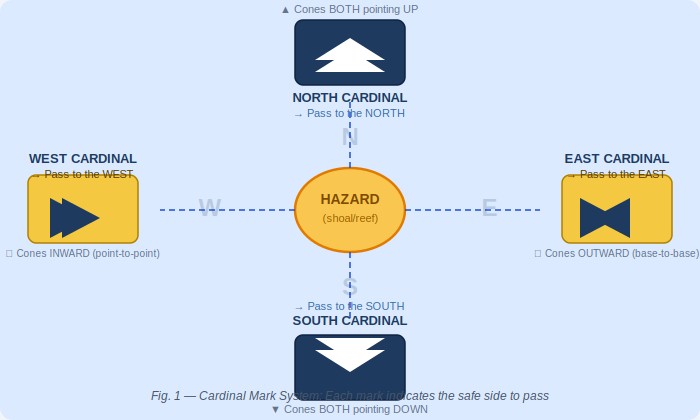
Fig. 1 — The Cardinal Mark System: Each mark signals safe water on its named compass side
The visual identity of cardinal marks is internationally standardised and deeply intentional. Each mark carries a combination of black and yellow bands, with the arrangement of those bands — and of the double-cone topmarks above — varying by direction:
- North Cardinal: both cones pointing UPWARD — pass to the north
- South Cardinal: both cones pointing DOWNWARD — pass to the south
- East Cardinal: cones base-to-base (pointing outward) — pass to the east
- West Cardinal: cones point-to-point (pointing inward) — pass to the west
After dark, each cardinal mark also displays a distinct flash pattern, ensuring that mariners relying on their night-watch do not need to approach closely to read the mark’s identity. The North Cardinal displays a continuous quick flash (Q); the South Cardinal a Q(6) plus a long flash every fifteen seconds; the East Cardinal a Q(3) every ten seconds; and the West Cardinal a Q(9) every fifteen seconds. These patterns are published in the Admiralty List of Lights and are reproduced on every official nautical chart.
In Nigerian waters — across the Gulf of Guinea, through the Niger Delta’s intricate web of channels, and along the coastline from Badagry to Calabar — cardinal marks play a critical role wherever shifting sediment, sandbars, or underwater obstacles create seasonal and permanent hazards. The lesson of the cardinal mark system is fundamental: knowing which side of the mark to pass is not optional knowledge. It is survival knowledge.
PART TWO: LATERAL MARKS — THE ROAD AT SEA
If cardinal marks define where the danger is, lateral marks define where the road is. The lateral mark system is among the oldest and most universally recognised in maritime navigation. It uses red and green buoys — and their associated shapes, light colours, and topmarks — to delineate the safe navigable channel through a port approach, a river, an estuary, or any defined waterway. Follow them like lanes on a highway, and your vessel stays in safe water.
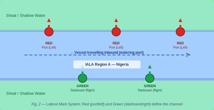
Fig. 2 — Lateral Mark System: Red (port/left) and Green (starboard/right) define the navigable channel
The world’s lateral mark system operates under two broad frameworks: IALA Region A and IALA Region B. Nigeria, like all African nations, falls under IALA Region A — meaning that when entering a channel from seaward, red marks are kept on the port (left) side and green marks on the starboard (right) side. This distinction is not academic. A vessel that mistakes its IALA region risks driving itself directly onto the hazard the lateral system was designed to avoid.
Red and Green: The Universal Lane Markers
Red lateral marks (port hand) in IALA Region A are cylinder- or can-shaped buoys displaying a red light. They mark the left side of the channel when entering port — the port hand. Green lateral marks (starboard hand) are conical buoys displaying a green light, marking the right side of the channel — the starboard hand. At channel junctions, modified lateral marks with red-green or green-red banding indicate the preferred route through divided waterways.
For fishermen operating in the creeks of the Niger Delta, for ferry operators crossing Lagos Harbour, for the crew of an LNG carrier threading the Escravos Channel, the lateral mark system is the spine of safe navigation. These marks define where the dredged channel lies, where water depth is adequate, and where the walls of the safe corridor begin and end. Ignore them and the consequences are mechanical, commercial, and sometimes fatal.
PART THREE: SAFE WATER MARKS — THE OPEN SEA SALUTE
If cardinal marks warn of danger and lateral marks define the channel, safe water marks do something simpler and altogether more reassuring: they confirm that you are in open, deep, unobstructed water. No shoals beneath you. No rocks to port or starboard. No channel restrictions. The safe water mark is the maritime equivalent of finding clear, open highway after hours of careful city driving.
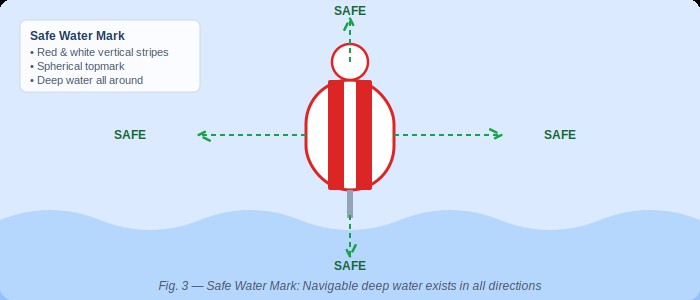
Fig. 3 — Safe Water Mark: Red and white vertical stripes signal navigable deep water in all directions
What a Safe Water Mark Tells You: A safe water mark — characterised by red and white vertical stripes, a spherical topmark, and either an Isophase, Occulting, or single long flash every ten seconds — signals that navigable deep water exists in all directions. No hazards. No restrictions. These marks are commonly positioned at the seaward approach to port channels, at the entrance to fairways, and at mid-channel positions in wide open passages. They are an invitation to proceed with confidence.
Safe water marks are frequently the first official marks a vessel encounters when approaching from deep ocean. Positioned at the start of a fairway, they signal to the navigator: the channel begins here — deep water, all clear. From that mark, the mariner picks up the lateral mark system and follows the defined channel inward toward berth.
For vessels approaching the Bight of Benin, making for the Tin Can Island terminals or the Apapa complex in Lagos, safe water marks serve as critical reference points for initial positioning. Offshore supply vessels heading for the deep-water oil terminals of the Niger Delta use them to confirm their approach corridors. Coastal traders rounding Cape Formoso watch for them as they transition from open sea to coastal navigation. In every case, the safe water mark is a confirmation, not a warning — a green light at the gateway to the port.
THE ARCHITECTURE OF MARITIME ORDER
It is worth pausing to consider the full elegance of what the navigation mark system represents. Across the world’s oceans — from the Arctic shipping lanes to the busy equatorial corridors of the Gulf of Guinea — vessels of every nation, crewed by seafarers of every language, follow the same colour codes, the same shapes, the same flash patterns. A Nigerian deck officer trained in Lagos can read the marks in Rotterdam harbour. A Dutch pilot brought aboard in Port Harcourt reads the marks in Bonny River as fluently as at home.
“The mark system is a universal language — one of the few truly global standards that requires no translation.”
The International Association of Marine Aids to Navigation and Lighthouse Authorities (IALA) maintains and evolves this system. Nigeria is a signatory to the IALA conventions, and the Nigerian Maritime Administration and Safety Agency (NIMASA), along with the Nigerian Ports Authority (NPA), bears responsibility for the placement, maintenance, and integrity of marks in Nigerian waters. Where marks are missing, damaged, or incorrectly positioned, the consequences range from commercial delay — a vessel that must anchor pending guidance — to catastrophe: a grounding that blocks a channel, spills cargo, or claims lives.
In recent years, concerns have been raised within the Nigerian maritime community about the state of navigational marking in some of the country’s secondary waterways — the creeks, river approaches, and coastal channels that serve Nigeria’s inland and nearshore maritime economy. The fishermen, ferry operators, and small cargo carriers who depend on these waterways navigate with imperfect information, sometimes relying on local memory rather than confirmed marks. Waterways News has documented incidents in the Niger Delta where absent or damaged marks contributed to groundings and near-misses. The case for investment in comprehensive, well-maintained navigation marking infrastructure along Nigerian waterways is not merely technical — it is an economic and safety imperative.
WHAT EVERY NIGERIAN SEAFARER MUST KNOW
Whether you are a vessel master bringing a bulk carrier into the Tin Can Island terminal, a crew-boat operator ferrying workers to an offshore platform, a fisherman navigating the channels of the Ijaw creeks, or a student at the Nigerian Maritime University in Okerenkoko preparing for your first sea posting — the navigation mark system is not optional knowledge. It is the foundation of safe maritime practice.
The three families of marks — Cardinal, Lateral, and Safe Water — together form a complete vocabulary for communicating hazard, direction, and clearance. They operate day and night, in clear weather and in fog, and they do so in silence, at a fraction of the cost of any active monitoring system. They require no electricity to understand. They require only training, attention, and respect for the system.
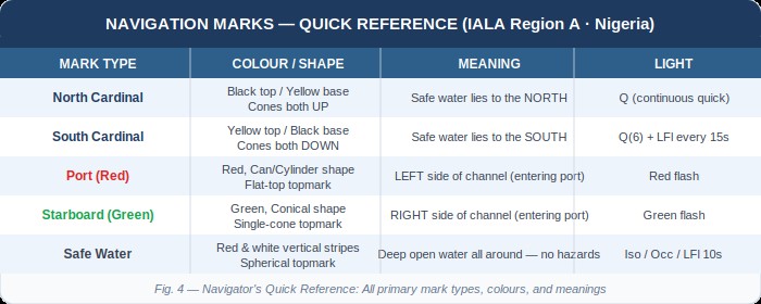
Fig. 4 — Navigator’s Quick Reference: Primary mark types, colours, and meanings at a glance
Enter deeper water safely. That is the promise — and the demand — of every navigation mark on every waterway in the world. It is a promise that only holds if mariners know the language, if authorities maintain the marks, and if the system is treated with the seriousness it deserves.
Waterways News will continue to monitor and report on the state of navigational infrastructure in Nigerian waters. We will advocate for adequate marking of the creeks, estuaries, and coastal approaches that form the backbone of Nigeria’s maritime economy. And we will continue to educate — because knowledge of the marks is the first line of safety at sea.
WATERWAYS NEWS | Report by Raymond Gold O., Co-publisher & Research Reporter | Navigation & Safety Desk • waterwaysnews.ng

Maritime Security and Safety
IMO Council Mourns Slain Seafarers, Demands Stronger Protection as Maritime Conflicts Deepen
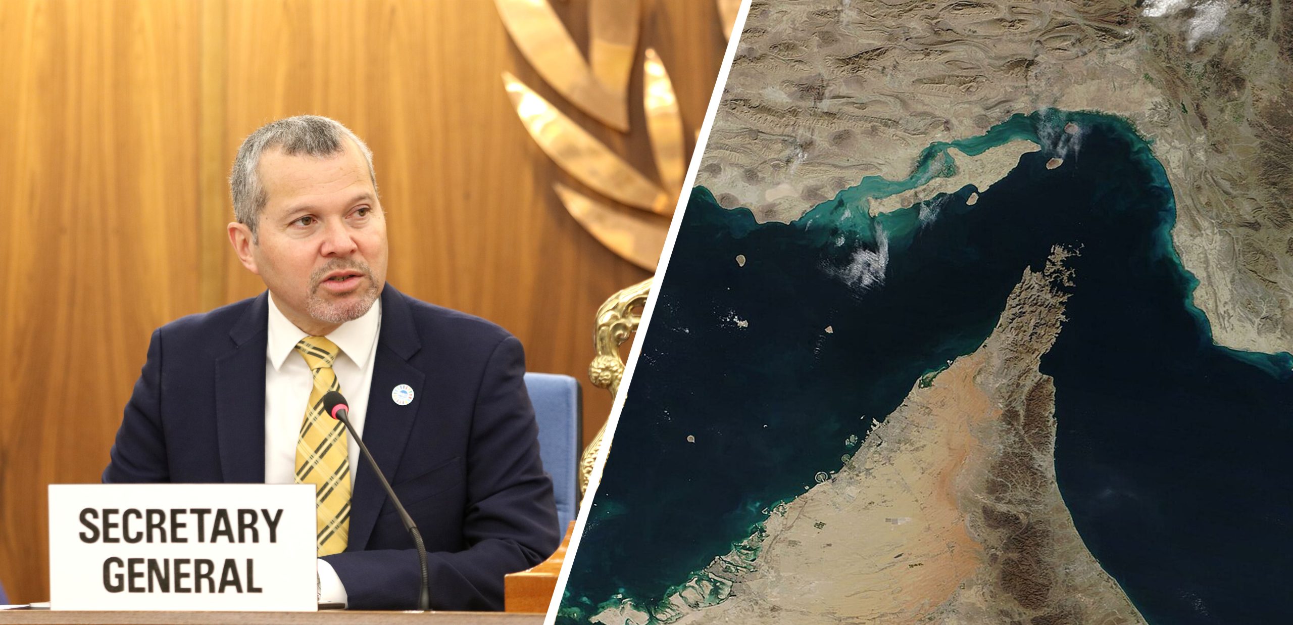
IMO Council Mourns Slain Seafarers, Demands Stronger Protection as Maritime Conflicts Deepen
Dominguez warns merchant ships remain exposed from Hormuz to the Black Sea as 138th Council session ends in London
By Okeoghene Onoriobe | Waterways News
Member states at the International Maritime Organization (IMO) used the opening of the Council’s 138th session to mourn seafarers killed in recent attacks and to demand firmer protection for civilian mariners.
Council met in London from 2 to 6 November, with Russia and Iran putting security in the Black Sea and the Strait of Hormuz at the centre of discussions. On 2 November, Secretary-General Arsenio Dominguez said commercial shipping remained exposed to attack in the Strait of Hormuz, the Red Sea, Bab el-Mandeb, the Eastern Mediterranean, the Black Sea and the Sea of Azov.
The mourning was driven by a run of deaths this year. Five seafarers reportedly died on 29 September during the rescue of the hijacked HONOUR 25 in Somali waters, and several others were seriously injured. In all, 44 seafarers were freed from three vessels. Dominguez noted that 22 seafarers remain captive aboard the ASANA, which was seized earlier this year, and urged continued effort to secure their release.
The Strait of Hormuz remains the deadliest flashpoint. The IMO had verified at least 70 attacks on international shipping there, with 19 seafarers killed, by its late-August assessment. A tally reported by gCaptain put the seafarer death toll at 24 as of 5 November.
Dominguez has repeatedly insisted that seafarers are civilians doing their jobs. He has said they should never become casualties of conflicts to which they are not a party.
Member states echoed the call. Liberia renewed its appeal for seafarer protection and freedom of navigation, and Indonesia said seafarer protection and safety of navigation must be a shared priority.
The session also dealt with leadership. Council backed a second four-year term for Dominguez, subject to approval by the IMO Assembly in 2027. The term would run from 1 January 2028 to 31 December 2031.
Nigeria Watch
Nigeria has more at stake than a distant diplomatic debate. Hormuz disruption has fed through to freight rates, war-risk insurance and port costs for Nigerian importers and shippers. Piracy off Somalia and the Gulf of Aden is a reminder that the Gulf of Guinea’s own security gains, including the Deep Blue Project, cannot be taken for granted.
The Council session also bears on Nigeria’s IMO seat. Abuja has pushed seafarer welfare and maritime security as part of its diplomacy, and the Council’s message gives that agenda more weight. The test is whether Nigeria backs its advocacy abroad with welfare protections, training and safety enforcement for its own mariners and for the informal waterway operators represented by WABOTAN and ATBOWATON.
For those operators, the lesson from London is that protection is a shared responsibility, and it has to reach the people who work on the inland water, not just those on ocean-going ships.
Nigeria Unveils Home-Built ADX-Barra 200 Autonomous Vessel at AFRIDEX 2026
Arridex, DICON joint venture Helagon delivers country’s first indigenously developed unmanned surface vessels%
By Ighoyota Onaibre | Waterways News
Nigeria has unveiled its first indigenously developed autonomous surface vessel, the ADX-Barra 200. Arridex Group, formerly RusselSmith Group, built it through Helagon, its defence joint venture with the Defence Industries Corporation of Nigeria (DICON).
The vessel was unveiled on 26 October at the inaugural Africa International Defence Exhibition (AFRIDEX 2026) at Eko Atlantic, Lagos. The exhibition ran from 26 to 29 October.
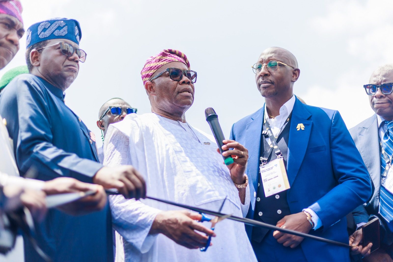
President Bola Ahmed Tinubu was represented by Senate President Godswill Akpabio. He said the administration prioritises defence industry growth because a nation is more secure when it can build and maintain its own capability. He described the vessel as that capability taking shape, designed and built by local engineers in partnership with DICON, and said it deserves government support and the confidence of the armed forces.
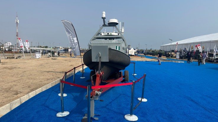
ADX-Barra 200
Arridex Group CEO Kayode Adeleke presented the vessel. He said Helagon was set up to design autonomous systems and that the ADX-Barra 200 is the result. For the forces that will use it, he called it a force multiplier.
The ADX-Barra 200 is one of two platforms in the ADX-Barra series launched at the exhibition. The other is the ADX-Barra 100. Arridex says both were designed, built and integrated in Nigeria by its engineers.
Adeleke tied the platforms to Gulf of Guinea security. He said the region’s waters carry its trade, support its coastal communities and hold much of its energy wealth, and that protecting them calls for capability the region can build, sustain and improve itself. He invited the armed services and other stakeholders to arrange demonstrations and to help shape later generations of the vessels.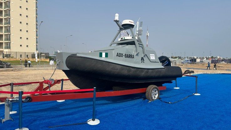
Others at the unveiling included Lagos State Deputy Governor Dr Obafemi Hamzat and the Minister of State for Defence, Dr Bello Matawalle. DICON Director-General Major General Babatunde Ibrahim Alaya, Helagon Chief Operating Officer Engr. Precious Omo-Agege and Arridex senior management were also present.
Arridex has not published the vessel’s technical specifications, including its length, endurance, payload and sensors. Both vessels remained on display at the exhibition.
NIGERIA WATCH
A home-built answer to a long-standing maritime problem: Nigeria’s waters have long needed more patrol capacity than its platforms and budgets can supply. A locally designed vessel that “can be supported, adapted and improved by the team that made it,” as Arridex puts it, addresses one persistent weakness. Imported hulls and systems often sit idle for want of spares, support and trained hands.
The questions that matter next: Unveilings are not deployments. The Navy, NIMASA’s Deep Blue Project and other agencies will want to know the vessel’s range, endurance, sensors and sea-state limits. They will also want to know whether it can work in the Gulf of Guinea. Until Arridex publishes specifications and arranges trials, the “game-changing” claim remains the company’s own.
Beyond defence: Waterways News readers should watch whether this technology filters into civil uses such as inland waterway surveillance, anti-vandalism patrols and search and rescue. The country’s inland operators, including those represented by WABOTAN and ATBOWATON, face insecurity and safety gaps that policy announcements have not closed. Local manufacturing capacity matters to them only if it eventually reaches the waterways where they work.
The accountability test: The industrial-policy argument is sound. It is build locally and maintain locally. It will be judged by procurement, deployment and sustained operation, not by launch-day speeches.
Editor's Choice
Australia Bars Repeat-Offender Bulk Carrier for 90 Days Over Falsified Crew Rest Records
Australia Bars Repeat-Offender Bulk Carrier for 90 Days Over Falsified Crew Rest Records
By Okeoghene Onoriobe | Waterways News
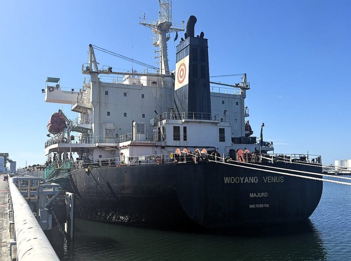
Australian maritime authorities have banned the Marshall Islands-flagged bulk carrier Wooyang Venus from its ports and waters for 90 days. Inspectors found that the ship’s crew work and rest-hour records had been deliberately falsified to hide excessive working hours.
The Australian Maritime Safety Authority (AMSA) boarded the vessel at the Port of Newcastle on 29 October after a complaint under the Maritime Labour Convention (MLC). Its port state control inspection found that the records did not match the hours the crew actually worked. The ship left Newcastle on 31 October for Korea, and the ban took effect afterwards.
This is the vessel’s third brush with Australian enforcement in under three years. AMSA detained it in August 2026 when crew hours were neither properly recorded nor monitored. It was first detained in December 2023, after a complaint from the International Transport Workers’ Federation (ITF).
That inspection found falsified hours records, poor food provisions and an allegation that the master had assaulted a crew member. AMSA’s annual MLC report says the operator then submitted a corrective action plan covering repatriation, better provisions and training on rest-hour compliance. The latest findings suggest those measures did not take hold.
AMSA Executive Director for Maritime Safety and Environmental Compliance, Greg Witherall, said falsifying records meant to protect seafarers undermines both crew welfare and ship safety. He warned that fatigue dulls judgement and slows reaction times, raising the risk of collisions, groundings and injuries, particularly during navigation and watchkeeping.
The ban was imposed under Section 246 of Australia’s Navigation Act 2012. AMSA cited the deliberate falsification, the repeated breaches and doubts over the effectiveness of the owner’s and operator’s safety management systems.
Nigeria Watch
The case matters for Nigeria for three reasons:
Records are the enforcement tool. Fatigue rules only work if rest-hour logs can be trusted. Australia treated falsification as a safety-system failure, not a paperwork lapse, and banned the ship rather than detaining it again.
Repeat offenders need escalating penalties. Two detentions and a corrective plan did not change this operator’s behaviour. Nigerian port state control should ask whether its own follow-up on repeat deficiencies has real consequences.
Seafarer welfare is a Nigerian issue. Nigerian seafarers serve on foreign-flagged ships, and those working boats and ferries on domestic waters face fatigue and welfare gaps too, often with no records at all.
The MLC regime Australia is enforcing shows what accountability looks like. It is the benchmark NIMASA and the inland regulators should be measured against, and one this publication will keep pressing.

 Oil and Gas8 months ago
Tantita’s Pipeline Deal: $144m Contract, Rising Output, and the Questions that Deserve Answers
 MARITIME TRADE & SHIPPING8 months ago
World’s Largest Container Ship Sets New Maritime Record with 22,233 TEUs on Single Voyage
 Blue Economy9 months ago
Nigeria’s Coast Guard Bill: A Solution in Search of a Problem?