
Maritime Security and Safety
Special Report: Know Your Navigation Marks

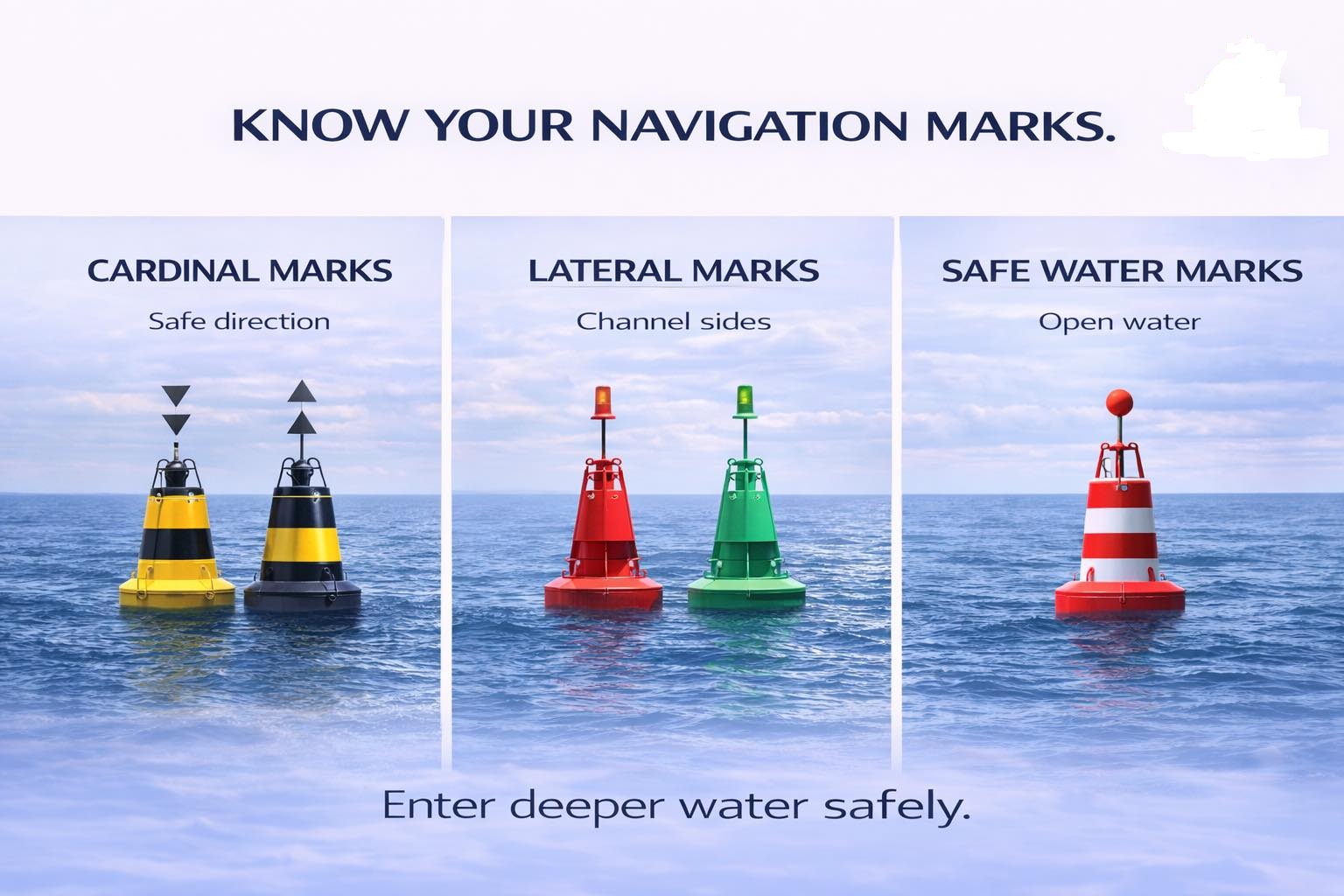

KNOW YOUR NAVIGATION MARKS
Out at sea, there are no roads, no lanes, no traffic lights — yet ships move safely every single day. Here is how.
SPECIAL REPORT | NAVIGATION & SAFETY :By Raymond Gold O. | Co-publisher & Research Reporter | Waterways News
The ocean is vast, unforgiving, and utterly unmarked by the familiar grid of roads that govern movement on land. No white lines divide one lane from another. No traffic officers wave ships into position. No overhead signs point toward a distant port. And yet, in one of the oldest and most remarkable feats of human coordination, thousands of vessels — from artisanal canoes to thousand-foot supertankers — navigate these waters in disciplined, near-flawless order. The secret is not technology alone. The secret is a universal language of marks.
Navigation marks are the vocabulary of the sea. They are the silent sentinels posted at critical junctures in the waterway — warning of danger here, confirming safe passage there, defining the channels through which commerce and livelihood flow. To the untrained eye, a buoy bobbing off the Lagos shoreline or the Niger Delta estuary may look like a modest piece of hardware. To the mariner who knows the system, it is as clear and authoritative as a highway sign. This special report, produced by the research desk of Waterways News, unpacks the three primary families of navigation marks that govern maritime movement the world over: Cardinal Marks, Lateral Marks, and Safe Water Marks.

“At sea, you don’t rely on instinct. You rely on marks, systems, and rules — and that discipline is what keeps every vessel alive.”
PART ONE: CARDINAL MARKS — WHERE SAFETY LIVES
Of all the mark types in use across the world’s shipping lanes, cardinal marks carry perhaps the most important directive: they do not tell you where to go, they tell you where it is safe to go. Positioned around a hazard — a reef, a shoal, a shallow bank, a submerged wreck — cardinal marks are named after the four principal compass directions: North, South, East, and West. Each mark tells the approaching mariner the side on which safe, navigable water lies.
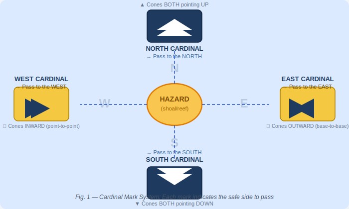
Fig. 1 — The Cardinal Mark System: Each mark signals safe water on its named compass side
The visual identity of cardinal marks is internationally standardised and deeply intentional. Each mark carries a combination of black and yellow bands, with the arrangement of those bands — and of the double-cone topmarks above — varying by direction:
- North Cardinal: both cones pointing UPWARD — pass to the north
- South Cardinal: both cones pointing DOWNWARD — pass to the south
- East Cardinal: cones base-to-base (pointing outward) — pass to the east
- West Cardinal: cones point-to-point (pointing inward) — pass to the west
After dark, each cardinal mark also displays a distinct flash pattern, ensuring that mariners relying on their night-watch do not need to approach closely to read the mark’s identity. The North Cardinal displays a continuous quick flash (Q); the South Cardinal a Q(6) plus a long flash every fifteen seconds; the East Cardinal a Q(3) every ten seconds; and the West Cardinal a Q(9) every fifteen seconds. These patterns are published in the Admiralty List of Lights and are reproduced on every official nautical chart.
In Nigerian waters — across the Gulf of Guinea, through the Niger Delta’s intricate web of channels, and along the coastline from Badagry to Calabar — cardinal marks play a critical role wherever shifting sediment, sandbars, or underwater obstacles create seasonal and permanent hazards. The lesson of the cardinal mark system is fundamental: knowing which side of the mark to pass is not optional knowledge. It is survival knowledge.
PART TWO: LATERAL MARKS — THE ROAD AT SEA
If cardinal marks define where the danger is, lateral marks define where the road is. The lateral mark system is among the oldest and most universally recognised in maritime navigation. It uses red and green buoys — and their associated shapes, light colours, and topmarks — to delineate the safe navigable channel through a port approach, a river, an estuary, or any defined waterway. Follow them like lanes on a highway, and your vessel stays in safe water.
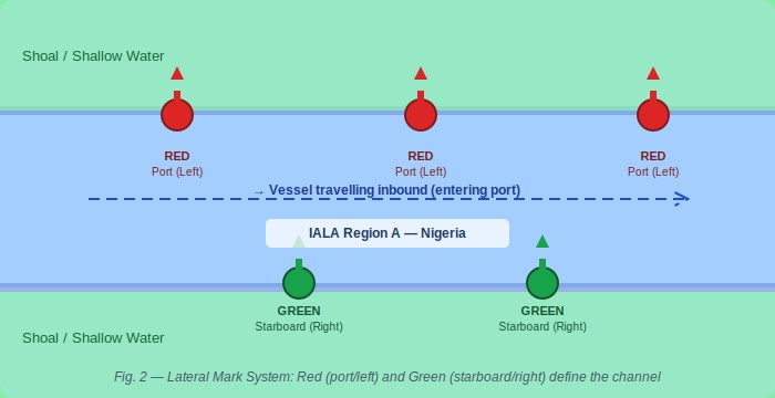
Fig. 2 — Lateral Mark System: Red (port/left) and Green (starboard/right) define the navigable channel
The world’s lateral mark system operates under two broad frameworks: IALA Region A and IALA Region B. Nigeria, like all African nations, falls under IALA Region A — meaning that when entering a channel from seaward, red marks are kept on the port (left) side and green marks on the starboard (right) side. This distinction is not academic. A vessel that mistakes its IALA region risks driving itself directly onto the hazard the lateral system was designed to avoid.
Red and Green: The Universal Lane Markers
Red lateral marks (port hand) in IALA Region A are cylinder- or can-shaped buoys displaying a red light. They mark the left side of the channel when entering port — the port hand. Green lateral marks (starboard hand) are conical buoys displaying a green light, marking the right side of the channel — the starboard hand. At channel junctions, modified lateral marks with red-green or green-red banding indicate the preferred route through divided waterways.
For fishermen operating in the creeks of the Niger Delta, for ferry operators crossing Lagos Harbour, for the crew of an LNG carrier threading the Escravos Channel, the lateral mark system is the spine of safe navigation. These marks define where the dredged channel lies, where water depth is adequate, and where the walls of the safe corridor begin and end. Ignore them and the consequences are mechanical, commercial, and sometimes fatal.
PART THREE: SAFE WATER MARKS — THE OPEN SEA SALUTE
If cardinal marks warn of danger and lateral marks define the channel, safe water marks do something simpler and altogether more reassuring: they confirm that you are in open, deep, unobstructed water. No shoals beneath you. No rocks to port or starboard. No channel restrictions. The safe water mark is the maritime equivalent of finding clear, open highway after hours of careful city driving.
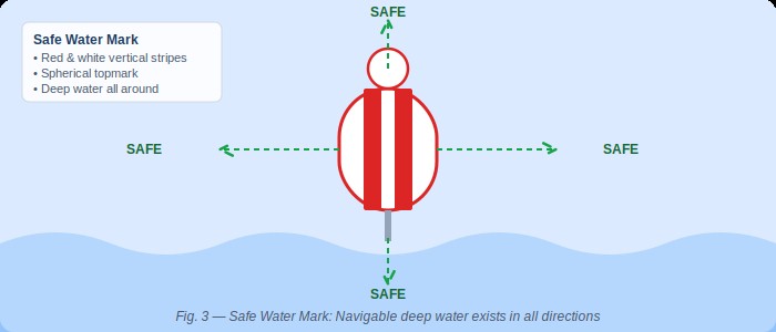
Fig. 3 — Safe Water Mark: Red and white vertical stripes signal navigable deep water in all directions
What a Safe Water Mark Tells You: A safe water mark — characterised by red and white vertical stripes, a spherical topmark, and either an Isophase, Occulting, or single long flash every ten seconds — signals that navigable deep water exists in all directions. No hazards. No restrictions. These marks are commonly positioned at the seaward approach to port channels, at the entrance to fairways, and at mid-channel positions in wide open passages. They are an invitation to proceed with confidence.
Safe water marks are frequently the first official marks a vessel encounters when approaching from deep ocean. Positioned at the start of a fairway, they signal to the navigator: the channel begins here — deep water, all clear. From that mark, the mariner picks up the lateral mark system and follows the defined channel inward toward berth.
For vessels approaching the Bight of Benin, making for the Tin Can Island terminals or the Apapa complex in Lagos, safe water marks serve as critical reference points for initial positioning. Offshore supply vessels heading for the deep-water oil terminals of the Niger Delta use them to confirm their approach corridors. Coastal traders rounding Cape Formoso watch for them as they transition from open sea to coastal navigation. In every case, the safe water mark is a confirmation, not a warning — a green light at the gateway to the port.
THE ARCHITECTURE OF MARITIME ORDER
It is worth pausing to consider the full elegance of what the navigation mark system represents. Across the world’s oceans — from the Arctic shipping lanes to the busy equatorial corridors of the Gulf of Guinea — vessels of every nation, crewed by seafarers of every language, follow the same colour codes, the same shapes, the same flash patterns. A Nigerian deck officer trained in Lagos can read the marks in Rotterdam harbour. A Dutch pilot brought aboard in Port Harcourt reads the marks in Bonny River as fluently as at home.
“The mark system is a universal language — one of the few truly global standards that requires no translation.”
The International Association of Marine Aids to Navigation and Lighthouse Authorities (IALA) maintains and evolves this system. Nigeria is a signatory to the IALA conventions, and the Nigerian Maritime Administration and Safety Agency (NIMASA), along with the Nigerian Ports Authority (NPA), bears responsibility for the placement, maintenance, and integrity of marks in Nigerian waters. Where marks are missing, damaged, or incorrectly positioned, the consequences range from commercial delay — a vessel that must anchor pending guidance — to catastrophe: a grounding that blocks a channel, spills cargo, or claims lives.
In recent years, concerns have been raised within the Nigerian maritime community about the state of navigational marking in some of the country’s secondary waterways — the creeks, river approaches, and coastal channels that serve Nigeria’s inland and nearshore maritime economy. The fishermen, ferry operators, and small cargo carriers who depend on these waterways navigate with imperfect information, sometimes relying on local memory rather than confirmed marks. Waterways News has documented incidents in the Niger Delta where absent or damaged marks contributed to groundings and near-misses. The case for investment in comprehensive, well-maintained navigation marking infrastructure along Nigerian waterways is not merely technical — it is an economic and safety imperative.
WHAT EVERY NIGERIAN SEAFARER MUST KNOW
Whether you are a vessel master bringing a bulk carrier into the Tin Can Island terminal, a crew-boat operator ferrying workers to an offshore platform, a fisherman navigating the channels of the Ijaw creeks, or a student at the Nigerian Maritime University in Okerenkoko preparing for your first sea posting — the navigation mark system is not optional knowledge. It is the foundation of safe maritime practice.
The three families of marks — Cardinal, Lateral, and Safe Water — together form a complete vocabulary for communicating hazard, direction, and clearance. They operate day and night, in clear weather and in fog, and they do so in silence, at a fraction of the cost of any active monitoring system. They require no electricity to understand. They require only training, attention, and respect for the system.
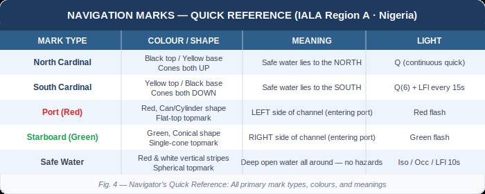
Fig. 4 — Navigator’s Quick Reference: Primary mark types, colours, and meanings at a glance
Enter deeper water safely. That is the promise — and the demand — of every navigation mark on every waterway in the world. It is a promise that only holds if mariners know the language, if authorities maintain the marks, and if the system is treated with the seriousness it deserves.
Waterways News will continue to monitor and report on the state of navigational infrastructure in Nigerian waters. We will advocate for adequate marking of the creeks, estuaries, and coastal approaches that form the backbone of Nigeria’s maritime economy. And we will continue to educate — because knowledge of the marks is the first line of safety at sea.
WATERWAYS NEWS | Report by Raymond Gold O., Co-publisher & Research Reporter | Navigation & Safety Desk • waterwaysnews.ng

Maritime Security and Safety
Shipping Lines Hail Security Gains as US Lifts 12-Year Condition of Entry on Nigerian Vessels
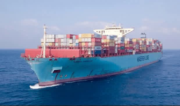
Shipping Lines Hail Security Gains as US Lifts 12-Year Condition of Entry on Nigerian Vessels
By Ighoyota Onaibre | Waterways News
International shipping lines operating in Nigeria have welcomed the United States Coast Guard’s (USCG) decision to remove the 12-year Condition of Entry (CoE) restriction on vessels arriving in the US from Nigerian ports, describing it as evidence of the country’s improved maritime security standing.
The CoE, in force since 2014, subjected vessels that had called at Nigerian ports within their previous five port calls to additional security checks and enhanced scrutiny before US entry. Its removal ends over a decade of extra costs, delays and paperwork for operators trading between Nigeria and the US.
Maersk’s Terminal Planning Lead for West Africa, Srijesh Subramanian, said the move would benefit both importers and exporters given the volume of Nigerian trade with the US, and would likely embolden shipping companies to expand their services. He read the decision as a signal that Nigeria now looks like a safer environment than previously perceived.
Ocean Network Express’s Nigeria Director, Stefan Pedersen, credited the outcome to NIMASA’s sustained work, though he noted ONE has no direct US sailings and so is not directly affected. He expects the removal of restrictions to still ease trade generally for lines that do run direct US services.
Pacific International Lines’ Managing Director, Ugo Opiah, framed the lifting as an image win: qualifying for US standards marks a country as a high-integrity player, and Nigeria’s decade-plus wait to clear the bar signals real improvement in maritime security compliance.
Mediterranean Shipping Company’s Vessel and Terminal Coordinator, Adesina Omoparuwa, said the restriction had forced MSC into trans-shipment routings rather than direct Nigeria–US calls, the same workaround the line uses for China, and that direct service should now become possible, opening opportunities for US-based businesses to trade directly through Nigerian ports.
Nigeria Watch
The CoE’s removal is the payoff of a process that has run since at least 2019, when the USCG first proposed a phased, bi-annual assessment track with NIMASA to bring Nigerian ports into full ISPS Code compliance. The agency conducted four full assessments of Nigeria’s port facilities and national maritime security framework between March 2024 and April 2026 before signing off.
Marine and Blue Economy Minister Dr Adegboyega Oyetola has called the lift a major milestone, crediting sustained collaboration between the Ministry, NIMASA, port and terminal operators and shipping lines. Washington has echoed that framing: in a letter dated August 26, 2026, US Assistant Secretary of State for African Affairs Frank Garcia congratulated Oyetola on the reform, tying it to Nigeria’s anti-terrorism and port-security compliance record.
For Nigeria’s port competitiveness push, running alongside the NPERA Act’s commencement and the deep seaport approvals at Badagry, Olokola, Ibom and Bakassi, the CoE exit removes one of the more persistent reputational drags on the sector: an active US security flag that shipping lines, insurers and freight forwarders had priced into Nigeria-bound trade for over a decade. Whether the savings in inspection time, insurance and freight cost are passed down to Nigerian shippers, or absorbed by the lines quoted here, is the next thing worth watching.
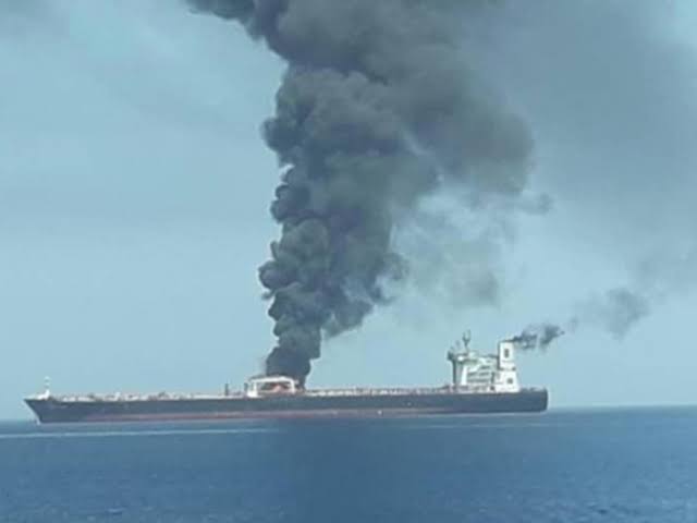
Two More Tankers Struck in Strait of Hormuz as Attack Count Hits Five in a Week
By Okeoghene Onoriobe | Waterways News
Two more tankers have been hit while transiting the Strait of Hormuz, leaving two seafarers with minor injuries and pushing the number of reported attacks or security incidents against commercial vessels in the waterway to at least five since 16 September.
The UK Maritime Trade Operations (UKMTO) centre said an inbound tanker was struck by an unidentified projectile on Monday. Two crew members sustained minor injuries, but the vessel stayed under its own power and continued to its next port, with no environmental impact reported.
Hours later, UKMTO issued a second alert after an outbound LPG tanker reported being struck by debris from unknown projectiles. All crew were reported safe and the vessel also continued its voyage. Authorities are investigating both incidents, and UKMTO has not attributed either attack to a specific actor.
The two strikes build on a Joint Maritime Information Center (JMIC) advisory covering three earlier attacks between 16 and 18 September, one of which saw a tanker’s hull breached by a projectile, sparking a fire. JMIC continues to rate the threat level in the strait as “severe,” citing a high likelihood of deliberate hostile action and pointing to a pattern of harassment by Iran’s Islamic Revolutionary Guard Corps — drone overflights, surveillance of merchant vessels and VHF hailing, alongside the direct attacks.
Traffic through the chokepoint remains sharply depressed. Only 17 commodity vessels were visibly transiting over the weekend, down from 37 the week before and against a pre-war daily average of roughly 125. That figure excludes vessels sailing with their AIS transponders switched off, and JMIC notes a persistent gap between visible and actual traffic.
Nigeria Watch
For Nigerian maritime stakeholders, the Hormuz crisis is no longer a distant Gulf story. It is a cost line. Every fresh escalation feeds directly into the war-risk insurance premiums and freight rates that Nigerian importers, refiners and shipping agents ultimately absorb, since global tanker and container capacity pulled off the Hormuz route tightens supply elsewhere and pushes rates up across long-haul trades, including those serving West African ports.
The renewed attacks also sharpen the stakes around Nigeria’s push for a stronger voice at the IMO Council table and its broader blue-economy diplomacy under Minister Adegboyega Oyetola. A sustained Gulf disruption is exactly the kind of systemic shock that tests whether Nigeria’s seat translates into influence over how global shipping risk, insurance and rerouting decisions are made, rather than Nigeria simply absorbing the downstream cost.
Locally, the episode is a reminder of the layered nature of “maritime security” as a policy word: the Deep Blue Project and Gulf of Guinea security architecture address piracy and armed robbery close to home, but Nigeria’s ports and shippers remain exposed to security failures thousands of kilometres away in the Gulf.
Waterways News will continue tracking how the Hormuz situation feeds into freight cost pressure at Nigerian ports and NIMASA’s public messaging on the issue.
Navy Renews Call for Special Maritime Courts, But Nigeria’s Justice Gap Persists
By Raymond Gold
The Nigerian Navy has again pressed for the creation of dedicated courts to try maritime offences, arguing that Nigeria’s regular judicial process is too slow to match the pace at which security agencies are arresting suspects at sea.
The renewed push came last week in Lagos at the 4th Ehingbeti Blue Economy Hub, on a panel built around strengthening the regulatory and justice frameworks needed to secure Nigeria’s blue economy. The session drew senior officers from the Navy and Marine Police, alongside a retired flag officer and other maritime stakeholders.
Rear Admiral A. A. Mustapha, Flag Officer Commanding the Western Naval Command, represented on the panel by his Chief Staff Officer, Rear Admiral N. C. Ekwom, said Nigeria is working toward an integrated maritime security strategy that would fold the country’s various security agencies into one common operating picture. He pointed to the Navy’s Falcon Eye system and the Regional Maritime Awareness Capability System as the technological backbone of that effort, noting that artificial intelligence is increasingly being layered onto surveillance operations.
Mustapha’s team acknowledged a persistent integration problem: the Navy’s Maritime Command and Control Centre reserves roughly 15 seats for personnel from partner agencies, but most command centres nationwide still operate in isolation. He linked the gap to a wider unfamiliarity with the sector across government, describing it as “maritime blindness”, a failure, in his words, to recognise the maritime domain’s importance to national development.
It was retired Rear Admiral Olanrewaju Beckley, however, who delivered the panel’s sharpest message: that slow prosecutions, not weak detection, may be the Navy’s biggest handicap. Beckley ran through the familiar list of threats I including illegal fishing, illegal bunkering, kidnapping for ransom, illegal refineries, terrorism and smuggling, and said the Navy’s “detect, arrest and prosecute” model breaks down at the final stage. Suspects and their vessels can sit in detention for extended periods awaiting trial, he said, a delay that risks suspects walking free and undermines the deterrent effect of every arrest made at sea.
His prescription was the same one Nigerian naval officers have floated repeatedly over the past decade: dedicated maritime courts that could fast-track case determination and cut down on prolonged detention without trial. Beckley also called for heavier government investment in surveillance assets such as vessels, drones and manned aerial platforms, arguing that the size of Nigeria’s maritime estate demands a security budget to match.
Assistant Inspector-General of Police Okunade Ronke Nurat, represented by CSP Olalekan Faniyi, described the working relationship between the Marine Police and the Navy as cordial, with joint patrols proceeding without friction, though she conceded there was room for deeper collaboration. Other panellists urged that any security-first approach to the blue economy be matched with investment in the coastal and riverine communities that live alongside Nigeria’s waterways.
The session’s recommendations, taken together, called for tighter integration among maritime security agencies, wider surveillance deployment, closer Navy–Marine Police cooperation, more security-asset funding, specialised judicial mechanisms for maritime crimes, and stronger economic support for coastal communities.
Nigeria Watch
Beckley’s plea will sound familiar to anyone who has followed this file. The Navy has asked for special maritime courts under at least three different Chiefs of Naval Staff over the past decade — through a Senate committee proposal in 2016, a direct appeal from the naval leadership in 2021, and now this latest call in 2026 — with no legislation to show for it. NIMASA’s leadership has separately lobbied the judiciary through its annual Admiralty Law Seminar for Judges, seeking faster case turnaround for the same reason Beckley cited: arrests that don’t stick because prosecutions crawl.
What has changed since 2020 is the legal toolkit, not the court structure. The Suppression of Piracy and Other Maritime Offences (SPOMO) Act gave prosecutors their first dedicated piracy statute and produced Nigeria’s first SPOMO conviction at the Federal High Court in Port Harcourt. But SPOMO cases still route through the same generalist Federal High Court dockets — carrying admiralty, commercial and constitutional matters alongside maritime crime — that Beckley says are the bottleneck. A special court, as envisaged, would need enabling legislation the National Assembly has never passed, whatever the number of naval appeals for it.
For operators represented by cooperatives like WABOTAN and ATBOWATON, the stakes in this debate cut both ways. Faster maritime prosecutions would, in principle, mean faster resolution for the vessels and crews the Navy detains, a genuine grievance among small-scale operators who say their boats and livelihoods can be tied up in custody for months over infractions far short of piracy or oil theft.
But any push to tighten enforcement and expand naval surveillance across the inland and coastal waterways will also be watched closely by the same informal operators, who have long argued that security crackdowns too often catch legitimate local transporters in the same net cast for pirates and illegal bunkerers. Whether the next iteration of this proposal survives the National Assembly, or joins its predecessors as a recommendation without a bill, will say much about how seriously Abuja is treating the justice half of its blue economy ambitions.

 Oil and Gas7 months ago
Tantita’s Pipeline Deal: $144m Contract, Rising Output, and the Questions that Deserve Answers
- MARITIME TRADE & SHIPPING7 months ago
World’s Largest Container Ship Sets New Maritime Record with 22,233 TEUs on Single Voyage
- Blue Economy7 months ago
Nigeria’s Coast Guard Bill: A Solution in Search of a Problem?