Maritime Security and Safety
Stella Maris Launches Front-line Safety Kits for Seafarers at Ukrainian Ports Amid Growing Global Maritime Tensions
Stella Maris Launches Front-line Safety Kits for Seafarers at Ukrainian Ports Amid Growing Global Maritime Tensions

Maritime welfare charity equips vessel crews with battlefield-grade medical supplies, multilingual air raid guides and shelter maps as missile and drone attacks on Black Sea ports escalate — with warnings that risks are multiplying across key global shipping corridors including the Strait of Hormuz.
By Raymond Gold | Co-Publisher & Research Reporter, Waterways News, Lagos
Monday, March 16, 2026 | Lagos
ODESA, UKRAINE / LAGOS — In one of the most direct responses yet to the dangerous reality facing merchant mariners in active war zones, international maritime welfare charity Stella Maris has launched a pioneering crew safety kit initiative tailored specifically for seafarers calling at Ukrainian ports — where missile and drone strikes have become a recurring threat to ships and the men and women who crew them.

The kits, funded through a partnership with Norwegian war risk insurer Den Norske Krigsforsikring for Skib (DNK), represent a tangible acknowledgement that thousands of seafarers continue to transit some of the world’s most dangerous maritime corridors every month — often with little more than instinct and experience to guide them when the sirens begin to wail.
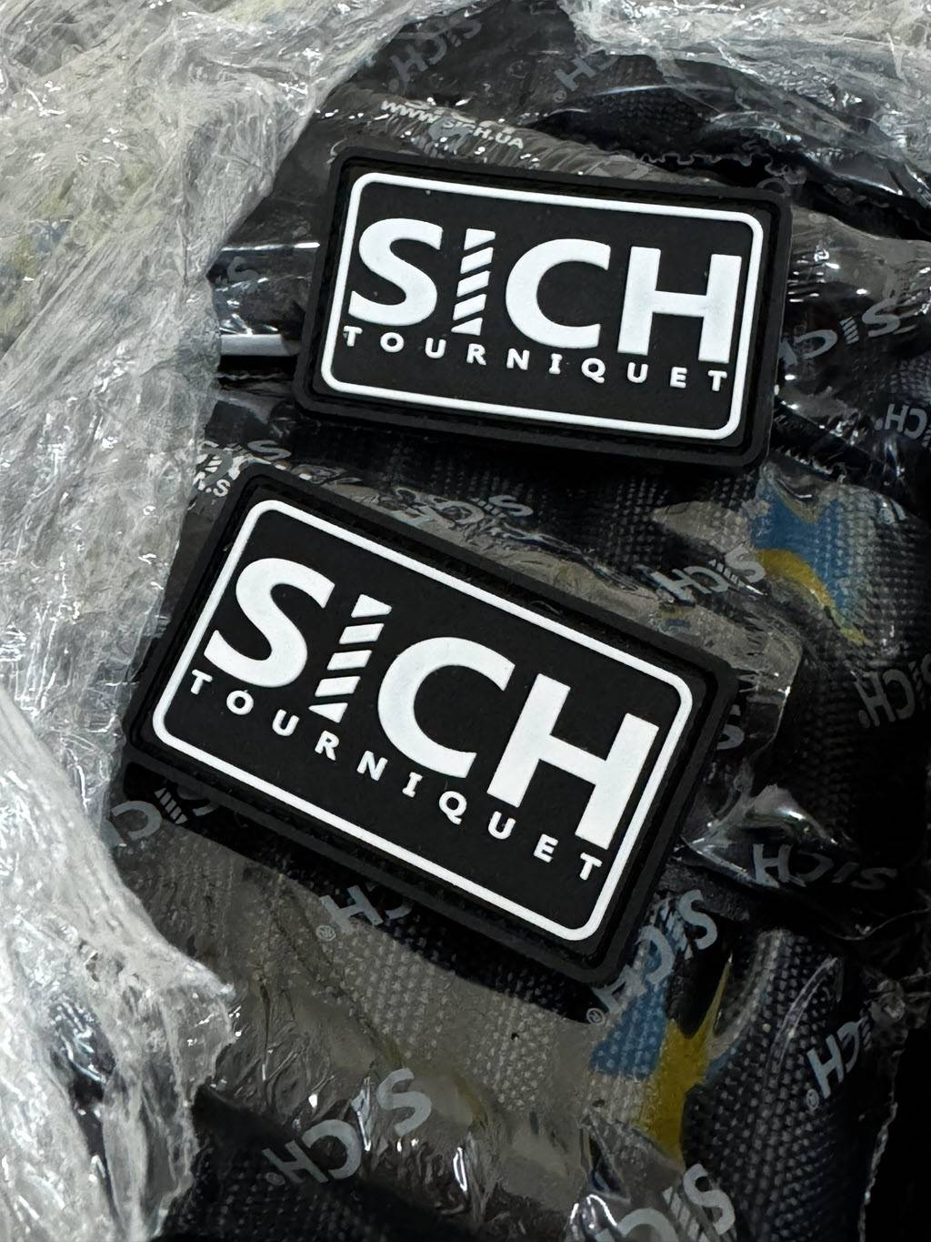
What Is Inside the Kit
Each crew safety kit has been assembled with battlefield-grade medical priorities in mind. The medical components include haemostatic tourniquets — the type routinely used by combat medics to halt life-threatening limb bleeding — as well as pressure bandages and burn treatment supplies designed to manage flash burns, a common injury type in blast and explosion scenarios.
Beyond the medical supplies, the kit addresses a gap that Stella Maris port chaplains have repeatedly observed at Ukrainian docks: crews arriving onboard without any knowledge of local emergency procedures. The kits therefore include printed step-by-step protocols to follow during an air raid alert, detailed maps marking the nearest public shelters, and information stickers formatted for display on ship bulkheads — ensuring critical guidance is visible at a glance even in conditions of extreme stress and time pressure.
Crucially, all instructional materials are multilingual, recognising that a typical vessel calling at Odesa or other Ukrainian ports may carry a crew drawn from the Philippines, India, Georgia, Turkey, Egypt, or a dozen other seafaring nations.
‘Preparedness Is Often the Only Thing You Can Control’
Father Alexander Smerechynskyy, Stella Maris Ukraine National Director and Odesa Port Chaplain, has been present for the harrowing reality that prompted the kits’ development. Stationed at one of the Black Sea’s most strategic and most targeted ports, he has watched foreign mariners disembark into a city that has endured repeated aerial bombardment, often bewildered by the sudden wail of air raid sirens and unsure where to run.
“Many overseas crews arrive without clear instructions on what to do during an air raid. In a war zone, preparedness is often the only thing you can control, and it can be the difference between life and death.”— Father Alexander Smerechynskyy, Stella Maris Ukraine National Director & Odesa Port Chaplain
Father Smerechynskyy stressed that the kit is more than a collection of objects. “Our safety kits provide not only essential medical equipment but also clear multilingual instructions, maps to shelters, and QR links to emergency guidance,” he said. “It is not just a set of items. It is a practical safety system designed to reduce panic and increase the chances of survival during an attack.”
DNK Funding and the Broader Strategic Context
The initiative has been made possible through funding from DNK — Den Norske Krigsforsikring for Skib — Norway’s specialist marine war risk insurer, which underwrites vessels trading into conflict-affected zones across the globe. DNK’s financial backing has enabled Stella Maris to produce and distribute the first wave of safety kits to ships currently calling at Ukrainian ports, with further distribution expected as demand grows.
The timing of the launch is significant. While the Russia-Ukraine war has dominated global maritime risk discourse since February 2022, the industry is simultaneously grappling with escalating tensions in multiple other critical corridors. In the Red Sea, Houthi missile and drone attacks have forced dozens of major shipping lines to abandon the Suez Canal route entirely, pushing vessels on costly and time-consuming diversions around the Cape of Good Hope. In the Gulf, jitters around the Strait of Hormuz — the narrow chokepoint through which roughly 20 percent of the world’s oil passes — continue to unsettle operators and insurers alike.
Stella Maris CEO: Seafarers Are on the Frontline of Conflicts They Didn’t Choose
Tim Hill, Chief Executive of Stella Maris UK, placed the Ukraine initiative within this wider landscape of growing danger for the maritime workforce — a largely invisible population that keeps global trade flowing even when the world around them descends into conflict.
“With geopolitical tensions increasing in several key shipping routes, including the current situation around the Strait of Hormuz, the risks faced by seafarers are growing. Crews are often on the frontline of global conflicts they have no part in. That makes practical preparation and clear safety guidance more important than ever for seafarers operating in high-risk regions.” — Tim Hill, CEO, Stella Maris UK
Hill’s remarks carry particular weight given the scale of the seafarer welfare crisis unfolding quietly at sea. Maritime labour experts estimate that at any given time, several hundred commercial vessels are transiting regions designated as high-risk zones by war risk underwriters — exposing tens of thousands of seafarers, the majority from developing nations, to dangers that their shore-based employers are often slow to adequately acknowledge or prepare them for.
Implications for Nigerian and West African Shipping
For Nigeria and West Africa’s maritime sector, the Stella Maris initiative serves as both a model and a reminder. Nigeria remains one of the most significant sources of maritime labour on the African continent, and a growing number of Nigerian seafarers serve aboard vessels engaged in deep-sea trades that routinely pass through or near conflict-affected waters. Industry observers have long called for shipowners and manning agencies to do more to equip Nigerian crew members with the safety awareness, protective gear, and emergency protocols necessary to survive in high-risk environments.
Port chaplaincy organisations with a presence in Lagos, Port Harcourt, and Warri are expected to watch the Stella Maris Ukraine model closely, as the Gulf of Guinea itself remains a zone of persistent maritime insecurity — albeit from piracy and armed robbery at sea rather than state-sponsored aerial bombardment.
A Practical Safety System for a Dangerous Age
The first wave of Stella Maris crew safety kits is already being distributed to vessels calling at Ukrainian ports. The charity has indicated that distribution will continue and potentially expand depending on available funding and demand from operators in other high-risk zones.
In an era when container ships are dodging missiles over the Black Sea and tankers are rerouting around the Red Sea to avoid drone strikes, the humble safety kit — with its tourniquet, its burn dressing, its hand-drawn map to the nearest air raid shelter — has become a symbol of a maritime industry still grappling with what it truly means to keep its most essential workers safe.
Stella Maris is the Catholic Church’s international seafarer welfare charity, operating across more than 300 ports globally. It provides pastoral, practical, and welfare support to seafarers of all faiths and nationalities.
Den Norske Krigsforsikring for Skib (DNK) is a Norwegian mutual war risk insurer specializing in hull and cargo war risk coverage for vessels operating in conflict-affected regions.

Maritime Security and Safety
PIRATES ROUTED AS EU NAVAL MISSION RESCUES HIJACKED IRANIAN FISHING VESSEL IN INDIAN OCEAN
PIRATES ROUTED AS EU NAVAL MISSION RESCUES HIJACKED IRANIAN FISHING VESSEL IN INDIAN OCEAN
By Okeoghene Onoriobe
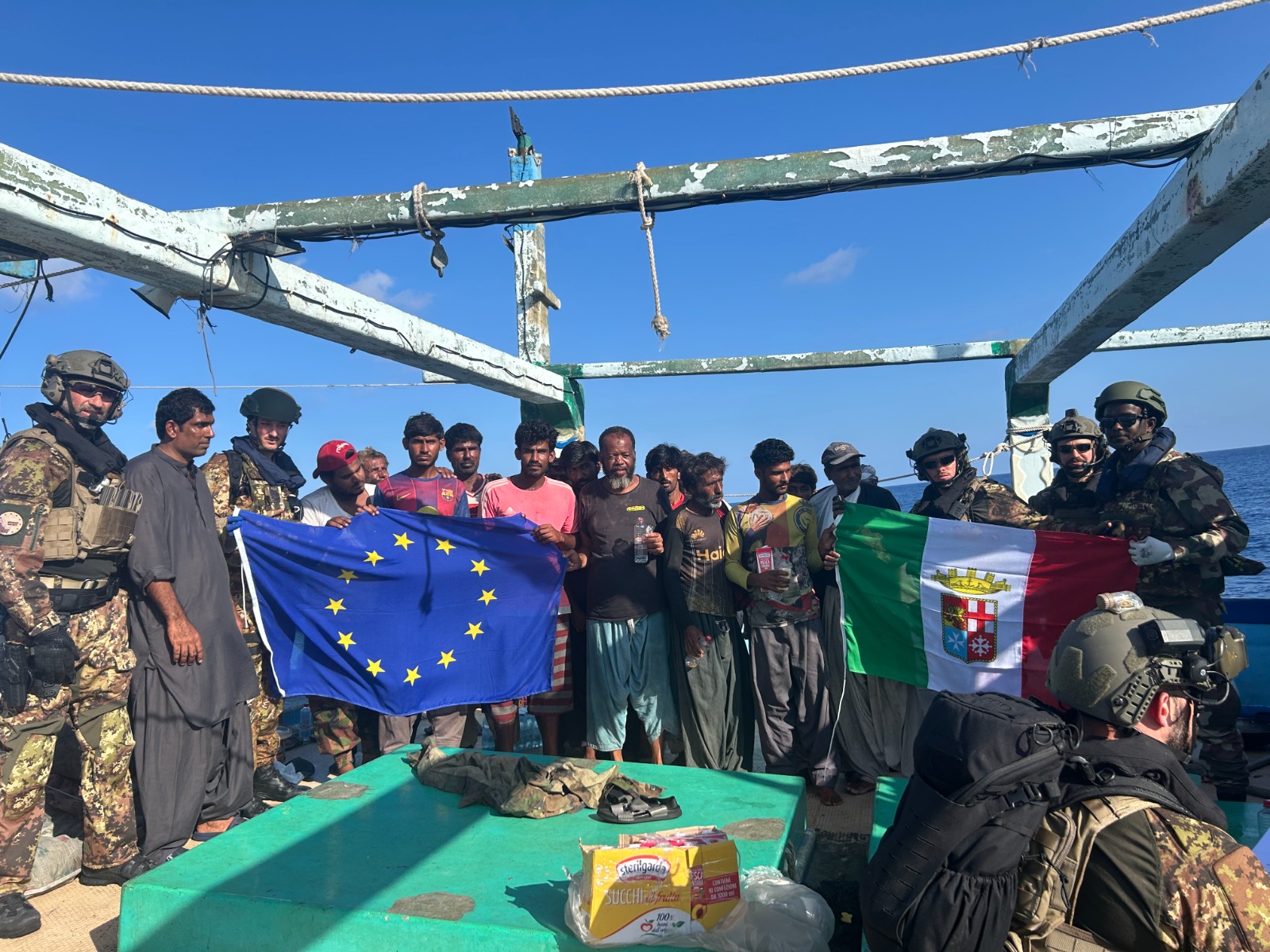
European naval forces have successfully freed a hijacked Iranian fishing dhow that had been held under pirate control for nearly two weeks in the Western Indian Ocean, in an operation that once again highlights the persistent threat of maritime piracy off the Horn of Africa.
The EU’s naval mission, EUNAVFOR Operation ATALANTA, confirmed that the Iranian-flagged vessel ALWASEEMI was liberated on Sunday after sustained military pressure compelled the pirates to abandon the ship and flee.
The fishing dhow had been seized on March 24 by a Pirate Action Group operating approximately 400 nautical miles east of Mogadishu. Intelligence indicated the pirates intended to deploy the vessel as a “mothership” — a floating base from which to launch attacks against larger commercial ships traversing the busy Indian Ocean shipping corridor.
Rather than mount a direct assault that could have endangered the crew, naval commanders opted for a methodical strategy described as the “concertina effect.” Working in close coordination with Somali maritime police, ATALANTA forces deployed warships and aerial assets to progressively tighten a surveillance net around the hijacked vessel, gradually eliminating the pirates’ room to manoeuvre.
The strategy worked. Cornered and under mounting pressure, the pirates disembarked along Somalia’s north-western coast and dispersed. Naval boarding teams then moved in, secured the vessel, confirmed the safety of all crew members, and provided food, water, and medical assistance to those on board. Evidence was also collected with a view to potential prosecution of the perpetrators.
The Maritime Security Centre Indian Ocean had earlier issued swift alerts to vessels in the region, advising ships to maintain safe distances and boost onboard security measures. By March 27, ATALANTA forces had already located and isolated the ALWASEEMI, ensuring it could not be used as a launchpad for further attacks.
The successful rescue operation drew on broad international cooperation, involving Somali security forces, the Combined Maritime Forces, and INTERPOL — a coalition that maritime security experts say remains indispensable for policing vast and vulnerable ocean corridors.
While Somali piracy had declined sharply from its peak in the early 2010s, the ALWASEEMI incident is among several recent cases signalling a troubling resurgence of activity in the region — one that observers link to broader geopolitical instability affecting key global shipping lanes and the livelihoods of seafarers worldwide.
Waterways News — www.waterwaysnews.ng
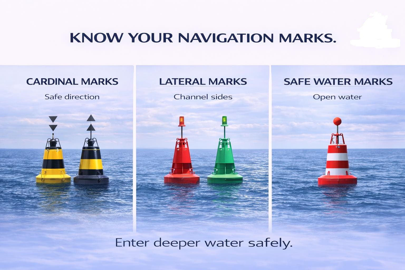
KNOW YOUR NAVIGATION MARKS
Out at sea, there are no roads, no lanes, no traffic lights — yet ships move safely every single day. Here is how.
SPECIAL REPORT | NAVIGATION & SAFETY :By Raymond Gold O. | Co-publisher & Research Reporter | Waterways News
The ocean is vast, unforgiving, and utterly unmarked by the familiar grid of roads that govern movement on land. No white lines divide one lane from another. No traffic officers wave ships into position. No overhead signs point toward a distant port. And yet, in one of the oldest and most remarkable feats of human coordination, thousands of vessels — from artisanal canoes to thousand-foot supertankers — navigate these waters in disciplined, near-flawless order. The secret is not technology alone. The secret is a universal language of marks.
Navigation marks are the vocabulary of the sea. They are the silent sentinels posted at critical junctures in the waterway — warning of danger here, confirming safe passage there, defining the channels through which commerce and livelihood flow. To the untrained eye, a buoy bobbing off the Lagos shoreline or the Niger Delta estuary may look like a modest piece of hardware. To the mariner who knows the system, it is as clear and authoritative as a highway sign. This special report, produced by the research desk of Waterways News, unpacks the three primary families of navigation marks that govern maritime movement the world over: Cardinal Marks, Lateral Marks, and Safe Water Marks.
“At sea, you don’t rely on instinct. You rely on marks, systems, and rules — and that discipline is what keeps every vessel alive.”
PART ONE: CARDINAL MARKS — WHERE SAFETY LIVES
Of all the mark types in use across the world’s shipping lanes, cardinal marks carry perhaps the most important directive: they do not tell you where to go, they tell you where it is safe to go. Positioned around a hazard — a reef, a shoal, a shallow bank, a submerged wreck — cardinal marks are named after the four principal compass directions: North, South, East, and West. Each mark tells the approaching mariner the side on which safe, navigable water lies.
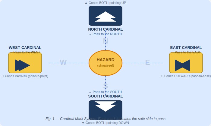
Fig. 1 — The Cardinal Mark System: Each mark signals safe water on its named compass side
The visual identity of cardinal marks is internationally standardised and deeply intentional. Each mark carries a combination of black and yellow bands, with the arrangement of those bands — and of the double-cone topmarks above — varying by direction:
- North Cardinal: both cones pointing UPWARD — pass to the north
- South Cardinal: both cones pointing DOWNWARD — pass to the south
- East Cardinal: cones base-to-base (pointing outward) — pass to the east
- West Cardinal: cones point-to-point (pointing inward) — pass to the west
After dark, each cardinal mark also displays a distinct flash pattern, ensuring that mariners relying on their night-watch do not need to approach closely to read the mark’s identity. The North Cardinal displays a continuous quick flash (Q); the South Cardinal a Q(6) plus a long flash every fifteen seconds; the East Cardinal a Q(3) every ten seconds; and the West Cardinal a Q(9) every fifteen seconds. These patterns are published in the Admiralty List of Lights and are reproduced on every official nautical chart.
In Nigerian waters — across the Gulf of Guinea, through the Niger Delta’s intricate web of channels, and along the coastline from Badagry to Calabar — cardinal marks play a critical role wherever shifting sediment, sandbars, or underwater obstacles create seasonal and permanent hazards. The lesson of the cardinal mark system is fundamental: knowing which side of the mark to pass is not optional knowledge. It is survival knowledge.
PART TWO: LATERAL MARKS — THE ROAD AT SEA
If cardinal marks define where the danger is, lateral marks define where the road is. The lateral mark system is among the oldest and most universally recognised in maritime navigation. It uses red and green buoys — and their associated shapes, light colours, and topmarks — to delineate the safe navigable channel through a port approach, a river, an estuary, or any defined waterway. Follow them like lanes on a highway, and your vessel stays in safe water.
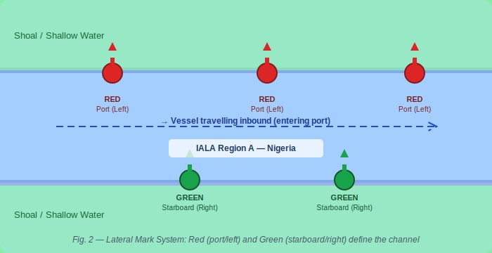
Fig. 2 — Lateral Mark System: Red (port/left) and Green (starboard/right) define the navigable channel
The world’s lateral mark system operates under two broad frameworks: IALA Region A and IALA Region B. Nigeria, like all African nations, falls under IALA Region A — meaning that when entering a channel from seaward, red marks are kept on the port (left) side and green marks on the starboard (right) side. This distinction is not academic. A vessel that mistakes its IALA region risks driving itself directly onto the hazard the lateral system was designed to avoid.
Red and Green: The Universal Lane Markers
Red lateral marks (port hand) in IALA Region A are cylinder- or can-shaped buoys displaying a red light. They mark the left side of the channel when entering port — the port hand. Green lateral marks (starboard hand) are conical buoys displaying a green light, marking the right side of the channel — the starboard hand. At channel junctions, modified lateral marks with red-green or green-red banding indicate the preferred route through divided waterways.
For fishermen operating in the creeks of the Niger Delta, for ferry operators crossing Lagos Harbour, for the crew of an LNG carrier threading the Escravos Channel, the lateral mark system is the spine of safe navigation. These marks define where the dredged channel lies, where water depth is adequate, and where the walls of the safe corridor begin and end. Ignore them and the consequences are mechanical, commercial, and sometimes fatal.
PART THREE: SAFE WATER MARKS — THE OPEN SEA SALUTE
If cardinal marks warn of danger and lateral marks define the channel, safe water marks do something simpler and altogether more reassuring: they confirm that you are in open, deep, unobstructed water. No shoals beneath you. No rocks to port or starboard. No channel restrictions. The safe water mark is the maritime equivalent of finding clear, open highway after hours of careful city driving.
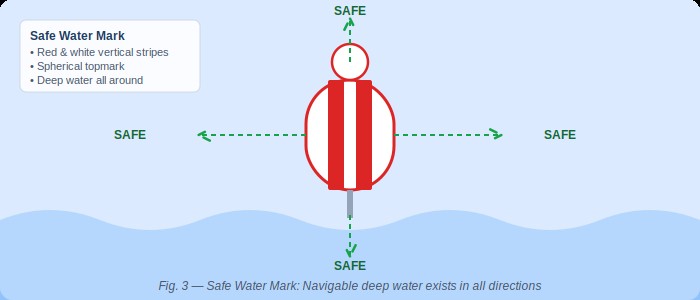
Fig. 3 — Safe Water Mark: Red and white vertical stripes signal navigable deep water in all directions
What a Safe Water Mark Tells You: A safe water mark — characterised by red and white vertical stripes, a spherical topmark, and either an Isophase, Occulting, or single long flash every ten seconds — signals that navigable deep water exists in all directions. No hazards. No restrictions. These marks are commonly positioned at the seaward approach to port channels, at the entrance to fairways, and at mid-channel positions in wide open passages. They are an invitation to proceed with confidence.
Safe water marks are frequently the first official marks a vessel encounters when approaching from deep ocean. Positioned at the start of a fairway, they signal to the navigator: the channel begins here — deep water, all clear. From that mark, the mariner picks up the lateral mark system and follows the defined channel inward toward berth.
For vessels approaching the Bight of Benin, making for the Tin Can Island terminals or the Apapa complex in Lagos, safe water marks serve as critical reference points for initial positioning. Offshore supply vessels heading for the deep-water oil terminals of the Niger Delta use them to confirm their approach corridors. Coastal traders rounding Cape Formoso watch for them as they transition from open sea to coastal navigation. In every case, the safe water mark is a confirmation, not a warning — a green light at the gateway to the port.
THE ARCHITECTURE OF MARITIME ORDER
It is worth pausing to consider the full elegance of what the navigation mark system represents. Across the world’s oceans — from the Arctic shipping lanes to the busy equatorial corridors of the Gulf of Guinea — vessels of every nation, crewed by seafarers of every language, follow the same colour codes, the same shapes, the same flash patterns. A Nigerian deck officer trained in Lagos can read the marks in Rotterdam harbour. A Dutch pilot brought aboard in Port Harcourt reads the marks in Bonny River as fluently as at home.
“The mark system is a universal language — one of the few truly global standards that requires no translation.”
The International Association of Marine Aids to Navigation and Lighthouse Authorities (IALA) maintains and evolves this system. Nigeria is a signatory to the IALA conventions, and the Nigerian Maritime Administration and Safety Agency (NIMASA), along with the Nigerian Ports Authority (NPA), bears responsibility for the placement, maintenance, and integrity of marks in Nigerian waters. Where marks are missing, damaged, or incorrectly positioned, the consequences range from commercial delay — a vessel that must anchor pending guidance — to catastrophe: a grounding that blocks a channel, spills cargo, or claims lives.
In recent years, concerns have been raised within the Nigerian maritime community about the state of navigational marking in some of the country’s secondary waterways — the creeks, river approaches, and coastal channels that serve Nigeria’s inland and nearshore maritime economy. The fishermen, ferry operators, and small cargo carriers who depend on these waterways navigate with imperfect information, sometimes relying on local memory rather than confirmed marks. Waterways News has documented incidents in the Niger Delta where absent or damaged marks contributed to groundings and near-misses. The case for investment in comprehensive, well-maintained navigation marking infrastructure along Nigerian waterways is not merely technical — it is an economic and safety imperative.
WHAT EVERY NIGERIAN SEAFARER MUST KNOW
Whether you are a vessel master bringing a bulk carrier into the Tin Can Island terminal, a crew-boat operator ferrying workers to an offshore platform, a fisherman navigating the channels of the Ijaw creeks, or a student at the Nigerian Maritime University in Okerenkoko preparing for your first sea posting — the navigation mark system is not optional knowledge. It is the foundation of safe maritime practice.
The three families of marks — Cardinal, Lateral, and Safe Water — together form a complete vocabulary for communicating hazard, direction, and clearance. They operate day and night, in clear weather and in fog, and they do so in silence, at a fraction of the cost of any active monitoring system. They require no electricity to understand. They require only training, attention, and respect for the system.
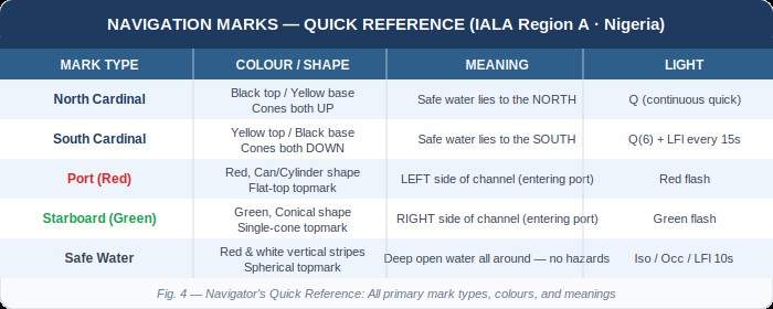
Fig. 4 — Navigator’s Quick Reference: Primary mark types, colours, and meanings at a glance
Enter deeper water safely. That is the promise — and the demand — of every navigation mark on every waterway in the world. It is a promise that only holds if mariners know the language, if authorities maintain the marks, and if the system is treated with the seriousness it deserves.
Waterways News will continue to monitor and report on the state of navigational infrastructure in Nigerian waters. We will advocate for adequate marking of the creeks, estuaries, and coastal approaches that form the backbone of Nigeria’s maritime economy. And we will continue to educate — because knowledge of the marks is the first line of safety at sea.
WATERWAYS NEWS | Report by Raymond Gold O., Co-publisher & Research Reporter | Navigation & Safety Desk • waterwaysnews.ng
Maritime Security and Safety
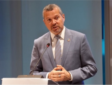
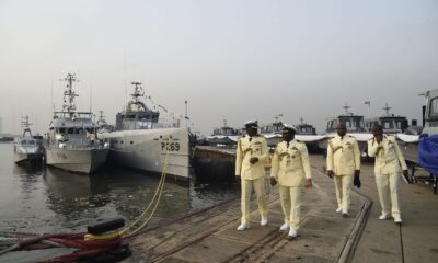
IMO Chief Demands Coordinated Global Response as Hormuz Crisis Leaves 20,000 Seafarers Stranded
IMO Chief Demands Coordinated Global Response as Hormuz Crisis Leaves 20,000 Seafarers Stranded
By Okeoghene Onoriobe | Waterways News Correspondent | Lagos
LAGOS — The Secretary-General of the International Maritime Organization (IMO), Arsenio Dominguez, has sounded the alarm over the deepening humanitarian and shipping crisis in the Strait of Hormuz, warning that piecemeal national responses are failing stranded seafarers and threatening the integrity of global trade routes.
Dominguez issued the call during a virtual high-level meeting convened by the United Kingdom’s Foreign, Commonwealth and Development Office, bringing together foreign ministers from more than 40 countries to assess conditions in one of the world’s most critical maritime chokepoints.
At the heart of the appeal is the fate of an estimated 20,000 seafarers who remain stranded aboard vessels in the Persian Gulf following a sharp escalation in hostilities that began on February 28, 2026. Since then, the IMO has recorded at least 21 attacks on commercial shipping in the region, leaving 10 seafarers dead and several others with serious injuries. Those still aboard vessels are enduring dwindling provisions, extreme fatigue, and mounting psychological strain.
Diplomacy Over Fragmentation
Dominguez was unequivocal in his assessment of what the crisis demands. “Fragmented responses are no longer sufficient to resolve this crisis. What is urgently required is diplomatic engagement, practical and neutral solutions, and coordinated international action,” he told ministers.
The IMO chief urged all parties to uphold freedom of navigation, protect the rights and welfare of seafarers, and support the establishment of humanitarian corridors to facilitate urgent aid delivery to affected vessels.
IMO’s Operational Response
Following an extraordinary IMO Council session held on March 18 and 19, the organisation has moved to operationalise a maritime evacuation framework built around cooperation with coastal states, verified security assurances, and industry-wide coordination.
Key measures already underway include efforts to guarantee safe passage for stranded crews, strengthen data collection and verification processes, and maintain supply lines to affected vessels. The IMO has also launched a dedicated online platform to provide verified, real-time information for seafarers and maritime stakeholders navigating the crisis.
The organisation is working in close partnership with major industry bodies — including BIMCO, ICS, ITF, INTERTANKO, and WSC — to enhance information sharing and mount a coherent sector-wide response.
UN Task Force Activated
The IMO is also participating in a newly established United Nations task force led by Jorge Moreira da Silva, Executive Director of the United Nations Office for Project Services (UNOPS). The task force draws in representatives from the United Nations Conference on Trade and Development (UNCTAD) and the International Chamber of Commerce (ICC), with a mandate to address the full range of humanitarian challenges unfolding in the region.
Dominguez reiterated that seafarers are neutral actors performing lawful duties and must not become pawns in geopolitical disputes. Describing the situation as “unacceptable and unsustainable,” he called on all stakeholders to take immediate, concrete steps to safeguard seafarers in line with their obligations under international law.
Nigeria Watch
How the Hormuz Crisis Touches Nigerian Maritime Interests
The escalating crisis in the Strait of Hormuz carries direct and compounding implications for Nigeria’s maritime sector, energy economy, and seafaring workforce.
Crude exports and tanker exposure. Nigeria remains a significant crude oil exporter, and a substantial share of Nigerian crude — particularly grades bound for Asian markets — transits routes that feed through or are priced against Persian Gulf benchmarks. Sustained disruption in the Hormuz corridor tightens global tanker supply, pushes spot fixture rates higher, and compresses margins for Nigerian charterers and terminal operators reliant on cost-competitive freight. The Dangote Refinery, now exporting refined products, is similarly exposed to tanker availability pressures in a disrupted market.
Nigerian seafarers at risk. Nigeria is one of Africa’s largest suppliers of maritime labour, with thousands of Nigerian officers and ratings serving aboard vessels globally. The possibility that Nigerian nationals are among the 20,000 seafarers stranded in the Persian Gulf cannot be discounted. NIMASA, as the flag state administration and the body responsible for the welfare of Nigerian seafarers internationally, should be urgently engaging the IMO’s evacuation framework and establishing a roster of Nigerian crew members currently operating in the affected corridor.
NPA and port throughput. If Hormuz disruption persists and rerouting via the Cape of Good Hope becomes a sustained reality — as was seen during the Red Sea crisis — voyage durations lengthen, vessel turnaround times extend, and cargo arrival schedules at Nigerian ports including Apapa, Tin Can Island, and Lekki Deep Sea Port become less predictable. Port operators and freight forwarders should be stress-testing their scheduling assumptions accordingly.
Policy signal for Abuja.
The IMO’s push for a multilateral evacuation framework and its engagement of coastal states is a prompt for Nigeria’s Federal Ministry of Marine and Blue Economy to signal its position. Nigeria’s standing within IMO governance structures — and its aspirations for a greater blue economy leadership role — would be enhanced by a formal statement of support for the IMO Secretary-General’s position and by offering, where feasible, logistical or diplomatic cooperation within the West African sub-region.
The Nigerian Shippers’ Council should also be monitoring freight rate developments closely, as prolonged Hormuz disruption historically feeds through to elevated surcharges on Nigerian import and export cargo — a burden ultimately passed to shippers and consumers.
-

 Oil and Gas4 weeks ago
Tantita’s Pipeline Deal: $144m Contract, Rising Output, and the Questions that Deserve Answers
-
 Blue Economy2 months ago
Nigeria’s Coast Guard Bill: A Solution in Search of a Problem?
-
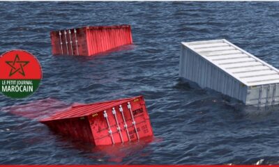
 Business1 month ago
CASABLANCA PORT SHUT DOWN AFTER VESSEL LOSES 85 CONTAINERS — SHIP SERVES NIGERIAN ROUTES